

In 8th January 2016, I formed this blog because of my frustration with lack of understanding of our situation in South Galway from some comments on my South Galway Floods Facebook page. I wrote What do you expect … when you built on a flood plain? in about 30 minutes in response to comments of the same name, published it and it had over 5000 reads within 24 hours. It highlighted that there were homes 200 years old that were flooding for the first time and that the builders of this didn’t build on a flood plain. However through the mismanagement of the Slieve Aughty mountains, land reclamation and other factors have now added flood risk to areas which weren’t initially prone to flooding.
The sentiment at the time is that some local authorities where granting planning permission in areas that were liable to flooding. There’s a recent development starting in Gort that has some people worried that they are building on a flood plain so lets take a very quick look at this. The site in question is Ballyhugh and is a substantial development comprising of :
- 132 houses
- 5 x single storey detached houses,
- 8 x detached 2 storey houses,
- 30 x 2 storey semi detached houses,
- 50 x storey semi-detached houses,
- 39 x 3 storey terraced houses.
- 6 x 2 bed apartments/creche /2 no. shop units in a 3 storey block.
- All associated site development works to include car parking, riverside walk/access, playground and amenity areas, roads, paths and boundaries/landscaping.
- All associated services
This is substantial development and it’s great to see this level of investment in development in Gort. My question – how have they considered flooding?
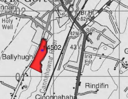
If we superimpose CFRAM maps (flood-risk management maps) from the Gort Local Area Plan 2013-2019, we get the following approximation.

This flooding extent seems to be a 23.5-24.2m contour and if we not look at these contours in relation to the proposal we get this:

Now that looks real bad! However, it’s not as bad as that though. That flood level is a 1 in a 100 year flood extent (happens on average once every 100 years) and it’s against the existing ground level. The development plans include raising the new ground level as shown in the diagram below.

So, in theory, this is on paper looks fine. This is a 1:100 year flood extent and finished floor level there could be approx 15-20 houses is about 1m above this extent, which again, seems reasonable. However, these flood extents are approximate and as we know the complexity of the hydrology of South Galway makes these numbers less accurate.
What concerns me is that while the developers did an initial flood risk assessment as a request for information – it didn’t seem trigger anything within OPW when it was first applied for. This assessment was pretty thorough and was completed in March 2009 and gave some extent information as shown here.

It also gave the recommendation that Minimum floor levels should be 25m ~about 1m above predicted extent – this was in line with OPW recommendations at the time of 500mm-600mm.
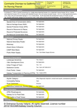
In 2014, planning permission extensions were sought and approved but again, these didn’t trigger any flooding risk (floodmaps.ie, Galway Co Co Flood Data and OSI ‘Liable to flooding’ areas ) despite the significant Winter 2009 flooding and the more recently developed CFRAM Maps (part of the Gort Local Area Plan 2013-2019)
In fact we can see here in Winter 2009 water gathering on the site opposite St Colman’s Park in the proposed development site.

Another factor is that as this development is raising land around a river bed, will it have an impact – yes – the 2009 analysis said that 1625m3 would be displaced but was not deemed significant (about 48 seconds worth of peak flow) . Maybe in the overall catchment this is deemed negligible but when downstream is given responsibility for taking up this and increased flows through Gort and other areas – they all add up but who is actually adding all of these up? It’s flooding by a 1000 cuts.
This kind of development is good for Gort and South Galway and from a flood risk perspective, it does seem to still have a 1m buffer zone which is portrayed as enough – but is this realistic? We should get more realistic flood relief extents at the end of the South Galway/Gort Lowlands Flood Relief feasibility study (End of 2019) and it will be interesting to see if this impacts on on the flood risk of this proposed development.
Hopefully not.
David Murray
Note : The Information on more recent CFRAM flood extent contours are approximate

How dare you question a local authority or local government or government for that matter. Don’t you realize that you are now living in a dictatorship with this administration. When this development goes ahead and receives it’s 1/100 year event every few years the answers will be twisted around to cover ass somehow. The attitude is one that they know all that needs to be known and why would we even consider to consult with locals in the real know. We had this first hand all thru the last flood. Hopefully there won’t be an election in the middle of the next flood, that would be too much to bear again. Remember the next flood is almost overdue again.
LikeLiked by 1 person
Thanks Shane!!
LikeLike
Great piece David. Up here in the lakeland zone the infill and draining of wetlands continues without let up and they wonder why flood levels are rising downstream. Cause and effect!
LikeLiked by 1 person
Agreed Brian!
LikeLike
David, I read that they were asking for a retention order, or am I mistaken? Why are they moving so slowly there now?
LikeLike
Heard something similar but haven’t been keeping an eye on it.
LikeLike